| 20200206-Maverick_helicopter_flight_into_Grand_Canyon_West_Rim | Return to http://www.kcmeyer.com |
| page 1 of 3 |
 |
 |
 |
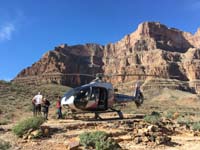 |
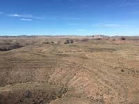
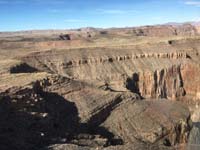
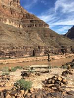
| 02-approaching_t... | 03-entering_the_... | 05-landed-wood_t... | 06-helicopter_an... |
 |
 |
 |
 |
| 08-scenery_looki... | 09-scenery_looki... | 10-scenery_looki... | 11-scenery_looki... |
01-taking_off.mov - [63 MB]
04-flying_through_the_canyon.mov - [378 MB]
07-scenery_from_landing_area.mov - [152 MB]
GCW-ABB-Maverick_helicopter_route.gdb
GCW-ABB-Maverick_helicopter_route.gpx
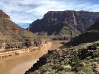
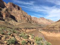
The pilot for the 12/9/2019 flight greeted the guests at the top of the hour walking them about 500 feet to the helicopter, provided the safety briefing, then boarded the helicopter taking off at 12:12 pm which was about 11 minutes after being greeted. The helicopter reached speeds of 190 mph while flying through the canyon traveling 11 miles taking 5.5 minutes. The helicopter looped around before landing. The helicopter was on the ground for about 17 minutes. The time on the ground included disembarking the helicopter, pictures in front of the helicopter, self-explore and picture, then re-boarding the helicopter. The guests enjoyed the canyon outside the helicopter for less than 15 minutes. The helicopter maintained speeds of about 100 to 110 mph, but then picked up speed when out of the canyon reaching almost 150 mph. The flight out was 7.1 miles taking 9 minutes. The helicopter landed at 12:43 pm. The total distance traveled was about 18 miles for about 31 minutes total flight time and experience in the Grand Canyon.
The pilot for the 2/6/2020 flight greeted us at the top of the hour walking us to the helicopter, provided the safety briefing and chatted along the way, then we boarded the helicopter taking off at 10:12 am. The top speed reached was 200 mph traveling 10.2 miles taking 5.5 minutes. The helicopter did not loop around this time so landed directly along the flight path. The time spent on the ground was about 21 minutes. The helicopter reached a maximum speed of 100 mph while flying in the canyon, but then reached 160 mph once beyond the canyon rim. The flight out was 7.5 miles taking 5.5 minutes. The helicopter landed at 10:43. The total distance traveled was about 17.7 miles for about 31 minutes total flight time and experience in the Grand Canyon.
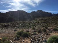
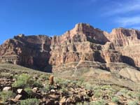
The Maverick landing spot is 3.5 miles ESE at a bearing of 115 degrees from the Hualapai Airport. It is about 200 feet above the Colorado River.